New autonomous reality capture sensors use robotic carriers and flying platforms to extend the ability to capture accurate as-built data.
Two new sensors from Hexagon are transforming the ability of industrial plant managers, engineers, owners and operators to capture comprehensive digital as-built data across entire facilities without putting workers in harm’s way.


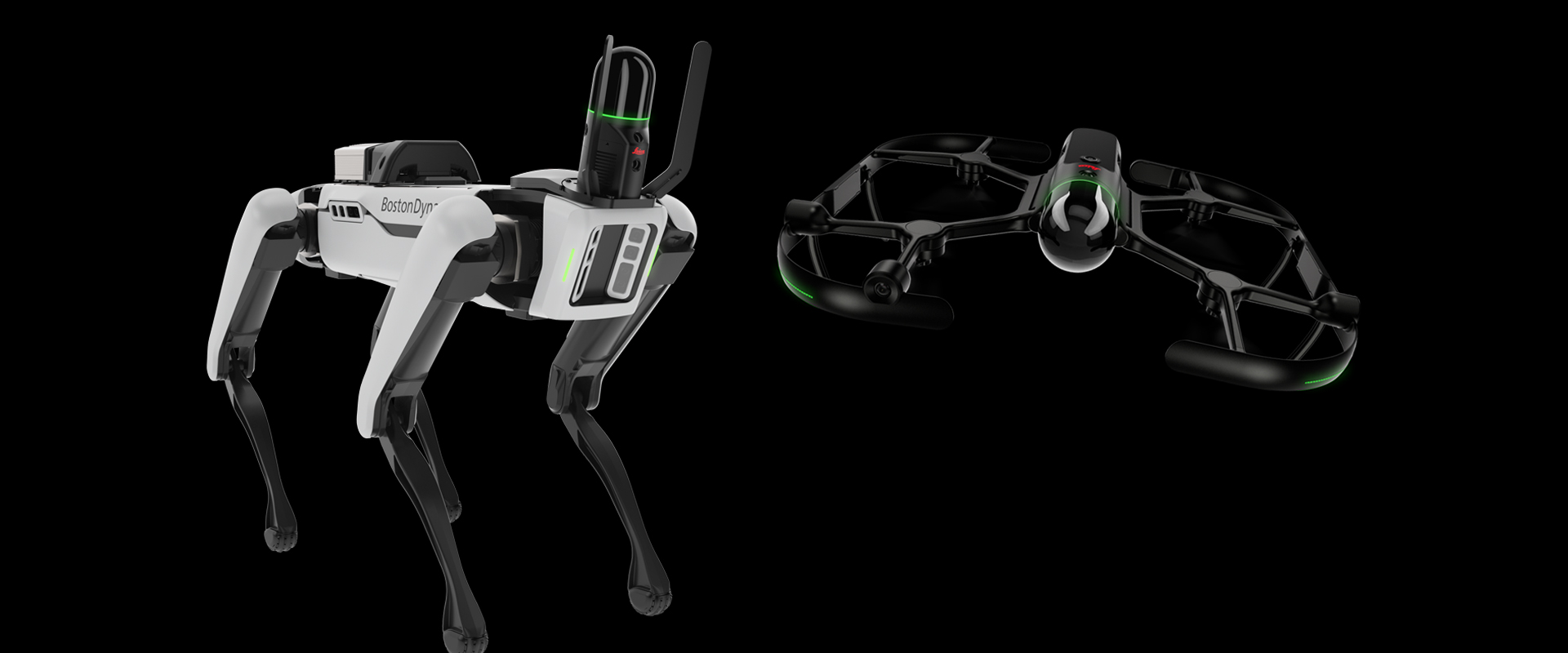
Scan in Dangerous or Hazardous Areas with Leica BLK ARC
The BLK ARC is a laser scanning sensor purposely built to improve the autonomous navigation of robots and other carrier platforms to deliver fully autonomous mobile laser scanning. Combining its speed, accuracy, and versatility with robotics, the BLK ARC addresses the growing demand for autonomous solutions that can safely and repeatedly capture accurate 3D point clouds and panoramic images of changing environments with minimal user intervention.
Scan in Inaccessible or Hard to Reach Areas with Leica BLK2FLY
The BLK2FLY is the world’s first fully integrated, autonomous flying laser scanning sensor. With a few simple taps on a tablet, users can quickly and easily scan structures and environments accurately and entirely from the air. The airborne scanning provides value across multiple industries in need of accurate data of inaccessible or hard-to-reach areas (e.g., façade projections, rooftops), ensuring complete capture of a structure’s exterior features and dimensions.
One of the things we learned from COVID is that digital asset management is imperative. With comprehensive digital as-built data on your facilities, you can have eyes on your facilities virtually from anywhere. You can make more informed decisions and streamline shutdowns and turnarounds. Autonomous sensors give you new ways to capture this information quickly and safely.
The BLK ARC and BLK2FLY connect directly to Hexagon’s cloud-based visualization platform, HxDR, where immediate data upload from the field, AI-enabled cloud processing and storage of the captured data enables instant delivery of a purpose-built smart digital reality to anyone who needs it.
While the BLK ARC can be easily integrated with other autonomous robotic carriers, the first robotic compatibility for the BLK ARC is with the Boston Dynamics Spot. As Spot carries the BLK ARC through an environment, the BLK ARC improves Spot’s navigation while capturing 3D data. The combination provides Spot greater autonomy with accurate laser scanning and navigation, enabling users to safely build 3D models of any area the robot can go.
The BLK2FLY introduces the next generation of flight safety with advanced autonomous obstacle avoidance. Sensor fusion of LiDAR, radar, cameras, and GNSS ensures optimal and safe flight paths. Users can seamlessly combine data from the BLK2FLY with interior scans of facilities and structures captured with the Leica BLK2GO, Hexagon’s handheld 3D scanner. The resulting colorized 3D point clouds are instrumental to digital asset management.
To learn more or request a demo, please contact us.
Digital Remote Management