Founded in 2004, F3 & Associates of Benicia, California, is a land surveying company specializing in industrial layout applications. In 2010, F3 acquired its first scanner, with additional purchases following quickly. 3D scanning led to 3D printing and metrology in subsequent years. Now F3 offers a workflow that combines these two technologies with augmented reality to benefit its clients in the petrochemical industry and beyond. In this 2014 interview, F3 Partner Sean Finn talks about this explosive growth.

Company
F3

Location
Benicia, CA

Why has 3D laser scanning become so popular in the petrochemical industry?
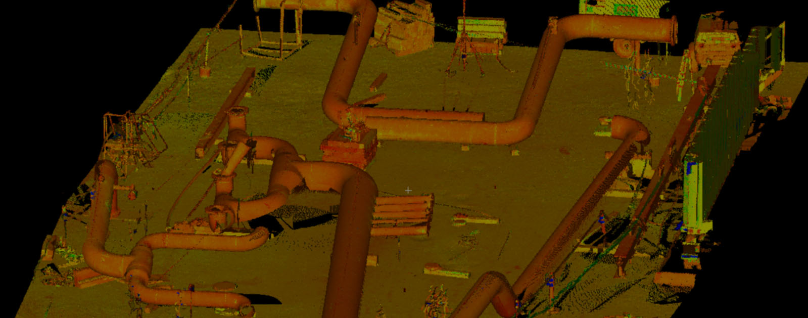
Sean: Before scanning technologies came along, huge petrochemical plants were modeled with a pocket tape and a clipboard. Essentially, the engineers and the team would try to route a pipe or as-built locations with pocket tapes and asymmetrical sketches. Laser scanning is a great way to capture an environment, maintain accuracy, and increase safety in projects ranging from in-kind component replacement, plant expansions, and capital improvements.
What are the biggest challenges involved in scanning and modeling petrochemical plants and related facilities?
Sean: A lot of the archive drawings don’t match the coordinate datums in the plant. We have to figure out what datum a scan is going to be on to match paperwork in the client’s hands. There are also a lot of safety requirements and paperwork that goes into place to start working in these environments.
What equipment do you prefer to use when you are out scanning one of these facilities?
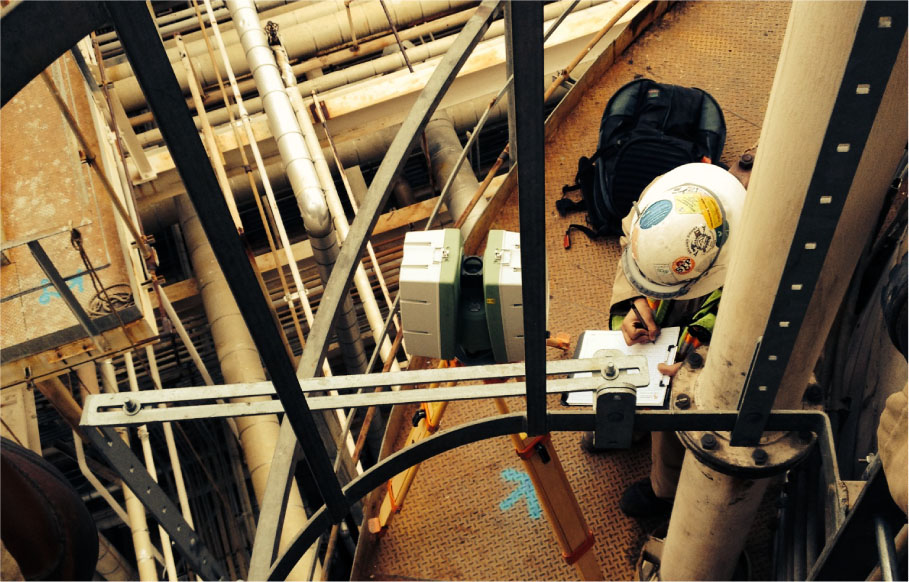
Sean: We use Leica ScanStation C10s and ScanStation P20s as well as Leica digital levels and transits. Leica Geosystems provides a good workflow and is a standard in the petrochemical industry—they’re part of the equipment listed in some of the specifications. We found that Leica 3D laser scanners have great range, generate rich cloud data, and are really the right type of scanner for petrochemical or any industrial environment. Other benefits include the ability to take photos at the same setup and the ability to adjust resolution on the fly and capture certain areas. Specifically, the survey workflow for both the C10 and the P20 allows us to know how we are fitting our control and our targets before getting to the office, so it is a great quality control check while we are in the field. Additionally our clients had a certain workflow that we wanted to make sure we could slide right into.
3D laser scanning provides a fast and easy way to capture a plant environment, maintain accuracy and increase safety. Leica Geosystems scanners are a standard in the petrochemical industry.
Do your guys in the field have to go through a lot of training to use these pieces of equipment and perform the actual scanning?
Sean: Yes. The software within the scanner is very user friendly, but target placement, setting the survey control networks and all that stuff prior to turning the scanner on is where your experts really need to invest their time. It takes a trained eye to understand where the scanner needs to be set up to capture an immense amount of data from different perspectives and at what resolution they need to run. So it is a process that we are constantly learning.
Does a field crew become specialized in scanning a petrochemical plant, scanning one type of plant versus another?
Sean: Yes. When you are talking about plants, from paper pulp to petrochemical to any other kind of energy or manufacturing facility, each has different safety hazards, so you have to prepare a mitigation plan. With petrochemical refineries, for example, there is a lot of elevated work, several stories high. You have hot pipes and hazardous conditions. When you get a crew that is comfortable in those environments and has a track record of performing high quality work safely, you definitely want to rely on them in those environments.
Each plant has different safety hazards, so crews often become specialized in their area of expertise.
Tell me a little bit about the workflow used in the field to collect the scans at a typical petrochemical plant project.
Sean: Each one is different. We typically set up by establishing what datum the client wants the data on. If it is going to be on a coordinate system that is monumented on the ground or if it is going to be an as-built set of plans that we have to match what those plans constrain to, the surveyor takes that datum and spreads it throughout the entire area using closed traverses, adjusted traverses, and high accuracy digital levels, and the ground control all gets put in place first. After the ground control is in place, we put targets in the entire environment—black and white targets or gray and white targets. Every scan setup has a minimum of five targets with coordinate geometry on them and that becomes the art form—how those targets get placed, how the scanner can hop around and have enough redundancy and coordinate geometry targets so it maintains accuracy. Once the targets are in place, they are then tied out by a land surveyor, and the scanning operation commences behind them.
Is there a common mistake or pitfall that you have to watch out for when scanning a petrochemical plant?
Sean: The common pitfall that we encounter is control datum. You have to understand where data needs to be georeferenced. Another pitfall is not understanding what the total envelope means. When you are collecting data for others, there is a responsibility to give them a very, very rich data set from the ground to the top. If that’s several stories, you have to get safely creative with man lifts and scaffolding to get the entire envelope of the data set. There is a certain art form even collecting just the right amount of data. Collect too much, and it bogs down the computers. If you don’t collect enough data, your client can’t do their job.
What was one of the most challenging scanning and modeling projects that you’ve done in the petrochemical field?
Sean: Recently we did a petrochemical facility where they asked us to scan an entire hydrocarbon cracking unit. The challenge here was the timeline and the immense volume of data that had to be collected—we had less than one month. We were one of the only firms that said we thought it would be possible. We used two Leica ScanStation P20s and two Leica ScanStation C10s. The P20s enabled us to go through the lower areas and collect really rich data sets very quickly at high resolution, while we used the C10s to step back a little bit and scan the higher elevations and higher columns. By utilizing the combination of all the scanners we were able to get this project done, have a team registering the point clouds in the office by sending hard drives back and forth nightly, and get the data set to our client in the time that they asked. We had six guys who worked six days a week in the field.
The survey workflow for both the Leica ScanStation C10 and Leica ScanStation P20 makes it easy to check quality in the field.
Sean: We typically use Leica Cyclone to stitch the scans together and to georeference them. From there we take the point cloud data into a CAD-based environment. The finish line could be a registered point cloud out of Cyclone or a 3D CAD model. The deliverable can be a paper product or a PDF where you are looking at a manufacturer or construction set of drawings. The finish line can also be a 3D print, in which we print out plastic replicas or scale models of the environments that we scan for our clients. These are usually desktop models that are used for project planning, safety meetings, a better understanding of the project and how it is going to be changed or added to. Or the submittal can be an augmented reality application that enables the client to “walk the job” with the point cloud data or the CAD-based data for use as a planning tool.
How does a 3D scan become a 3D print?
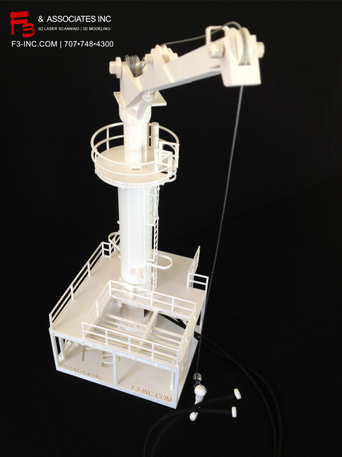
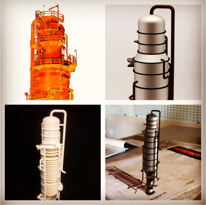
Sean: First we talk with the client about the scale of the model, or how big the replica should be. That’s usually cost-driven, but you don’t want to make the printed model so small that important features get lost. For the printing, first we collect the point cloud data and model it into a water-tight solid. Then it goes into our print software, and one of our in-house 3D printers prints it from the ground up. We use the Fortus and Dimension lines of printers from Stratasys, which have an almost 2-foot build space, are fast and are within .003 inch accuracy.
The internal parts of the petrochemical plant units are challenging to print in 3D. It’s hard to get access, so we’ve developed a way that we scan the outside of say a coker unit, and then we use the archived plans to model what is on the inside of that coker unit—which is sometimes 400 feet tall all the way from the snout to the base. So the client can have confidence that the measurements of the outside of the unit and the insides of the unit are based on manway locations or nozzle locations. Then the 3D print can open up like a dollhouse, and the entire thing can come apart.
Does the quality of the scanning on the front end impact the quality of the 3D printing products on the back end?
To find out how to transform your plant with digital data or request a consultation, please contact us.
Sean: Absolutely. The richness of the point cloud is what makes everything come together. So the better your registration and the better the resolution on the point cloud data, the better the print. And honestly, that also produces more savings for the client because the richer the data set is, the less time you spend modeling it into a water tight solid. There are some programs that will wrap it for you automatically if the data set is rich enough.
A high-quality 3D print requires good registration and point cloud resolution.
How does augmented reality play into this process?
Sean: Augmented reality is a way that you can take your point cloud data with survey accuracy and you can model things that are going to happen or things that are hard to see. In the field, you place QR codes that maintain a relationship with the digital model so the client can walk through with an IPad or Google Glass or other handheld device containing the 3D model data. By tripping that QR code with the device, he can access and see underground utilities modeled in 3D and in accurate locations on the device’s screen. He can see where a pipe is going to tie in. He can see a beam that is going to be put in later. That 3D CAD model just blends in through the camera function right in the screen you are holding, to scale and in the correct location. Again, it’s just another way of communicating. It’s a visually based planning tool.
One example of this application was a job we did at a Bay area refinery. They were going to route a major pipe through a very congested area, and it seemed no matter how many times I was invited to a job walk with the owner and the people who were going to do the work, no one could really grasp the route of this pipe with the asymmetrical drawings. So we set up an augmented reality application for the next job walk and placed a few QR codes in locations that were critical. Everyone was then able to gather around the tablets that were accessing the augmented reality with a scaled 3D CAD model and actually see how the new pipe was going to affect and have relationships with the existing facility.
How do augmented reality and Google Glass work together?
Sean: Google Glass is a hands free device that can work just like the camera function in your phone. As the client walks through the environment with the Google Glass and sees a QR code, they can scan that QR code with the Glass, and that loads up a relationship embedded in the memory file of the Glass—a 3D CAD model that will illustrate what they want to look at or what you want your client to see. It can be a future piping design that is going to occur in the facility right where he is standing, or it can be underground utilities that aren’t otherwise visible. It can be metadata related to a pump, for instance, that says when the pump was installed, when it is due for inspection, when it is due for swap-out, who made it, who installed it. All that data can be loaded on that Google Glass, and we as a service provider can put that QR code on a sign or in the cement so that information is accessible in the field.
Augmented reality allows you to take a point cloud data with survey accuracy and model things that aren’t yet in place or are difficult to see. F3 calls its patent-pending workflow Augmented Industrial™.
Does Google Glass have the ability to retrieve data from the cloud, for instance, or do you physically have to load data into a chip in the glass itself?
Sean: When it comes to Google Glass, the model is actually loaded onto the device itself. With iPads or tablets, it can be either one. The problem with a cloud-based system, however, is that you need to have a tablet that has cell phone capabilities or there has to be WIFI within the area.
What other industries are using, or maybe should be using, the integration of scanning, 3D printing and augmented reality?
Sean: Any facility that operates on a large scale and for long periods of time throughout the day needs to have this technology in their plant. I wish I could videotape the reaction when we drop a plastic model on someone’s desk or when we deliver a 3D CAD model to somebody who hasn’t used one for the first time. Giving the clients the ability to visualize their products through these tools and this technology … it is just a matter of time before everything is done this way.
For more information about F3, visit www.f3-inc.com.
HIGH-VALUE DELIVERABLES
- High resolution registered point clouds
- Photographs
- 3D plastic prints
- Augmented reality visualizations
BENEFITS
Increased Safety
All data captured from ground level
Fast Data Collection
1 month vs. 6 months
Comprehensive Data Capture
Complete and accurate as-is dataset can be reused for future projects
Reduced Downtime
Perfect-fit installation means no rework
Better Project Visualization
3D models, 3D prints and augmented reality visualizations enable stakeholders to make better decisions