6 Safety Advantages of Laser Scanning in Industrial Plant Environments
[With laser scanning], we’re actually capturing everything we can see that’s out of reach. The Safety Group has become one of the big advocates for using the technology in the plant because it helps them understand how to keep people out of potentially hazardous situations.
—John Brown, GM Reality Capture Supervisor
Every 99 minutes, someone in the U.S. dies from a work-related injury. An additional 2.8 million people are likely to sustain non-fatal workplace injuries or illness this year, with approximately 15 percent of these incidents occurring in manufacturing.*
While adherence to rigorous safety standards and training is helping to reduce these numbers over time, more efforts are needed to safeguard workers and prevent accidents. Increasingly, industrial plants are turning to digitization as a primary safety strategy.


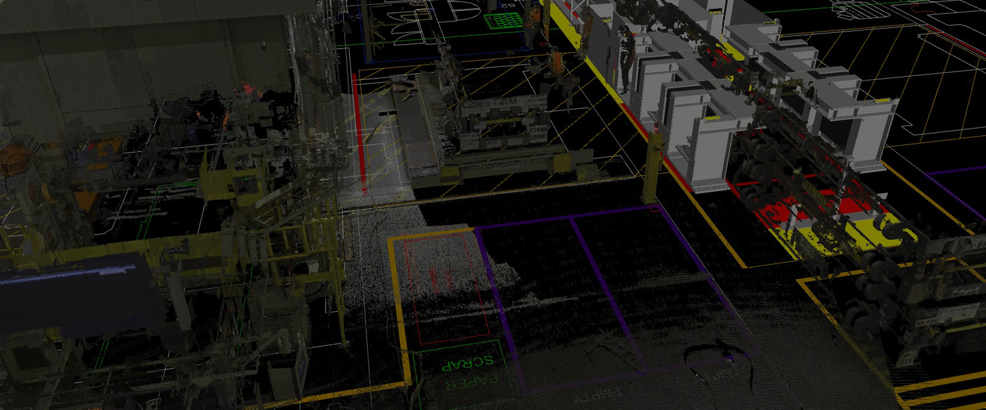
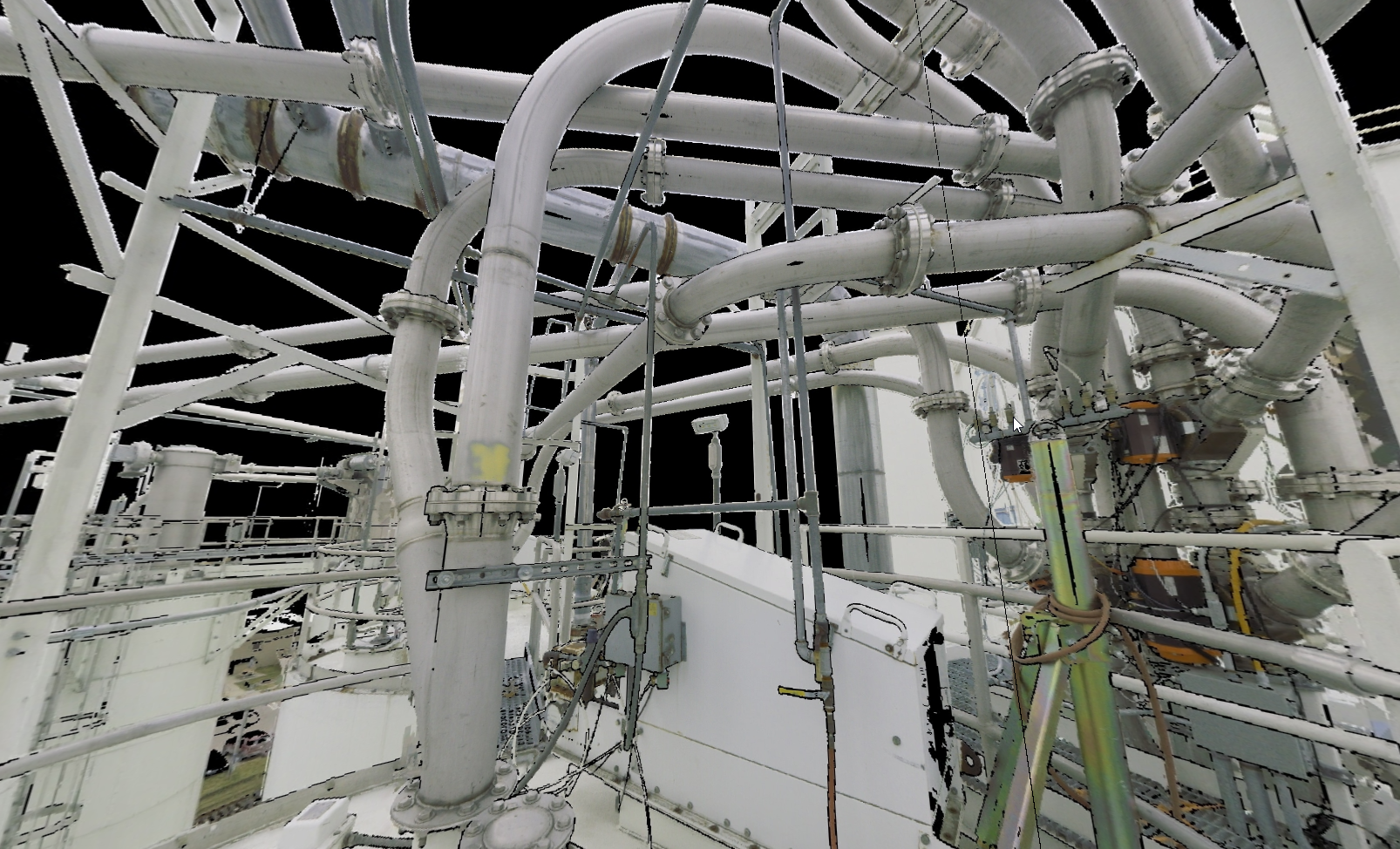
With reality capture technology such as 3D laser scanning, accurate as-built data can be safely and quickly captured across an entire plant to create a comprehensive digital twin.
A noncontact and nondestructive method of digitally capturing physical objects in 3D using a beam of light, or laser, 3D laser scanning has long been the standard for surveyors and engineers to obtain accurate measurements and complete as-built documentation for plant retrofit and upgrade projects.
Within the last several years, laser scanners have been developed that make it possible to complete a full scan in as little as 26 seconds. Software advances have made working with point clouds fast and easy, even when integrating point cloud data into existing CAD workflows.
As a result of these and other developments, employees across organizations as well as outside contractors are finding increasing value from point cloud data captured with 3D laser scanning.
Even more importantly, a digital remote management strategy built on a solid foundation of accurate, comprehensive point cloud data is helping facilities transform the safety of their operations. Here are six key safety benefits you can expect to see with laser scanning.
1. Reduced Need for Lifts and Ladders
The noninvasive nature of laser scanners allows accurate, comprehensive data to be captured from a distance. Instead of donning harnesses, climbing ladders, or erecting and balancing on scaffolding, personnel can quickly obtain all the data they need from safe locations on the ground. The technology does not require machinery to be shut down or for scanner operators to be in close contact with other people or with the equipment to capture measurements.
What’s more, the data is comprehensive and actionable, giving decision-makers extraordinary insight into the condition and capacity of tanks, piping and other equipment.
The new tower fit perfectly, and no modifications were necessary.
CASE IN POINT
An oil and gas processing company needed to replace a corroded 90-foot-tall tower on an amine stripper. Measuring the tower through traditional means would have required the hazards of climbing ladders and scaffolding along with days of work to document the measurements and create the models. Using a Leica RTC360 laser scanner, engineers scanned the piping from the ground in a matter of hours and used the point cloud to quickly model the tower and piping to ensure a new tower could be fabricated offsite without visits from the manufacturer.
“It was a shining success,” said the project lead. “The new tower fit perfectly, and no modifications were necessary. Having that peace of mind of knowing that when you get this piece of equipment it’s going to fit—that’s very valuable.”
2. Minimizing Exposure to Hazardous Environments
As-built measurements and inspections often must be performed in areas of a plant that involve dangerous fumes, radiation, confined spaces or other hazardous environments. Minimizing worker exposure in these environments is imperative.
Here, too, digitization with 3D laser scanning provides a solution. With a laser scanner, you can capture complete, accurate information from a distance quickly. In fact, the fastest laser scanner available completes a full scan in as little as 26 seconds. This means you can capture comprehensive data in a fraction of the time compared to other measurement methods. All of this data can be collected safely with a single operator working alone.
Once the data is captured, cloud-based software enables you to quickly and easily access the data from anywhere on any device, even if you aren’t familiar with CAD or 3D datasets. You can virtually visit the site without any safety concerns or delays, take snapshots, make measurements, and create markups with notes and links.
The Leica scanners were capable of capturing full-volume, 360-degree, 3D point clouds in about three minutes. Some rooms required only a single setup, which resulted in minimal exposure times to the harsh nuclear environment.
CASE IN POINT
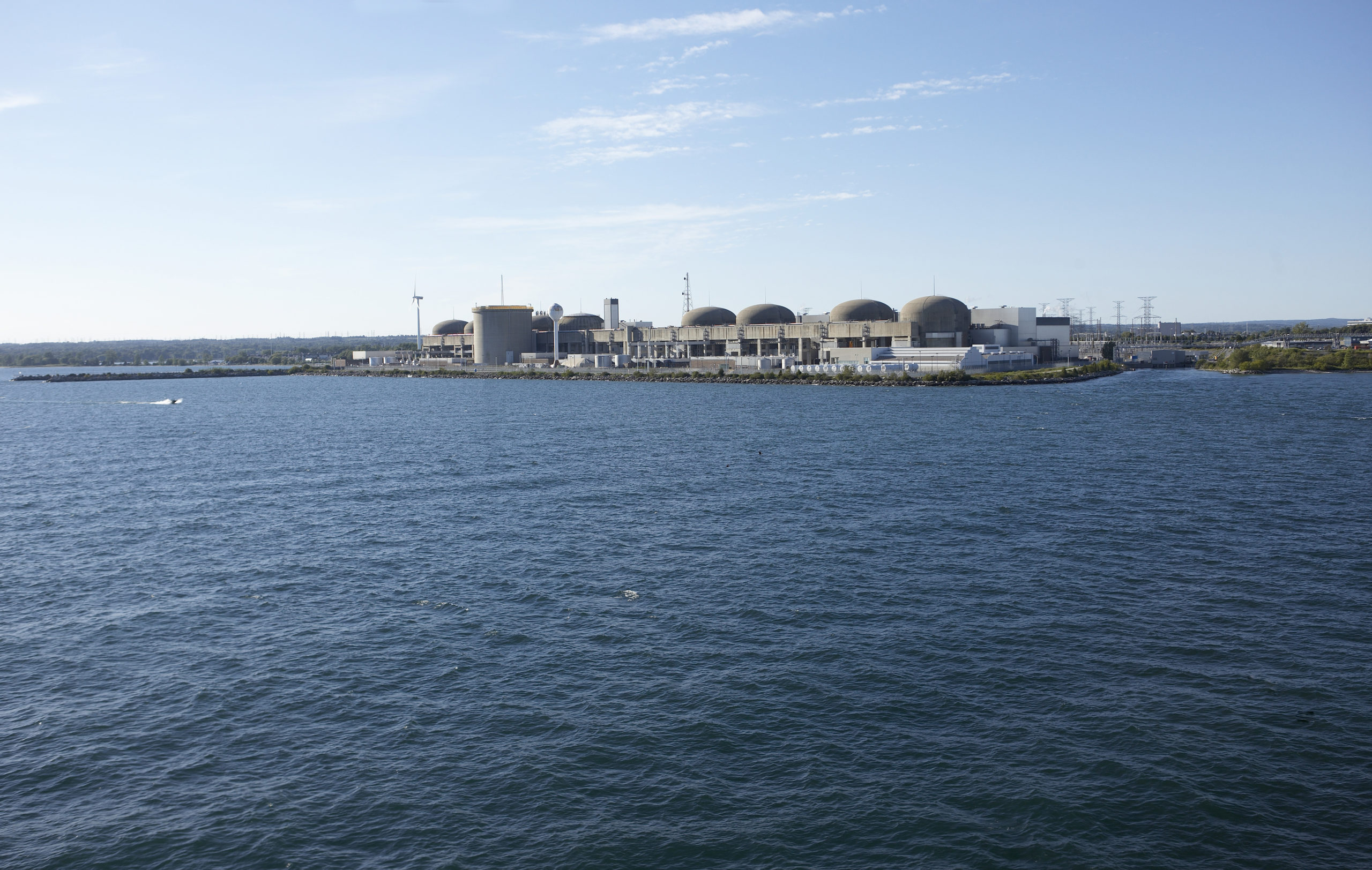
A nuclear power plant needed to assess potential corrosion in critical pipe systems in a pressurized water reactor. Identifying the high points and installing vents would alleviate any trapped gas, but manual methods would expose personnel to high levels of radiation, potential contamination and unsafe processes using ladders and scaffolding.
The solution was to use 3D laser scanning. While wearing full radiation-protection suits, personnel scanned piping from safe locations on the ground in more than two dozen rooms throughout the power plant using Leica P-Series professional-grade laser scanners. The Leica Geosystems scanners captured full-volume, 360-degree, 3D point clouds in about three minutes. Some rooms required only a single setup, which resulted in minimal exposure times to the harsh nuclear environment. Once a scan is initiated, the data acquisition is completely automated, allowing the operator to retreat to low-dose areas while critical data continue to be captured by the scanner.
3. Reduced Need for Fall-Protection PPE
As-built measurements and inspections often must be performed in areas of a plant that involve dangerous fumes, radiation, confined spaces or other hazardous environments. Minimizing worker exposure in these environments is imperative.
Here, too, digitization with 3D laser scanning provides a solution. With a laser scanner, you can capture complete, accurate information from a distance quickly. In fact, the fastest laser scanner available completes a full scan in as little as 26 seconds. This means you can capture comprehensive data in a fraction of the time compared to other measurement methods. All of this data can be collected safely with a single operator working alone.
Once the data is captured, cloud-based software enables you to quickly and easily access the data from anywhere on any device, even if you aren’t familiar with CAD or 3D datasets. You can virtually visit the site without any safety concerns or delays, take snapshots, make measurements, and create markups with notes and links.
Instead of capturing a couple hundred measurement points on a tank, we were able to safely capture millions or billions of highly accurate points from the ground, which provided much more clarity on the tank’s condition and status.
CASE IN POINT
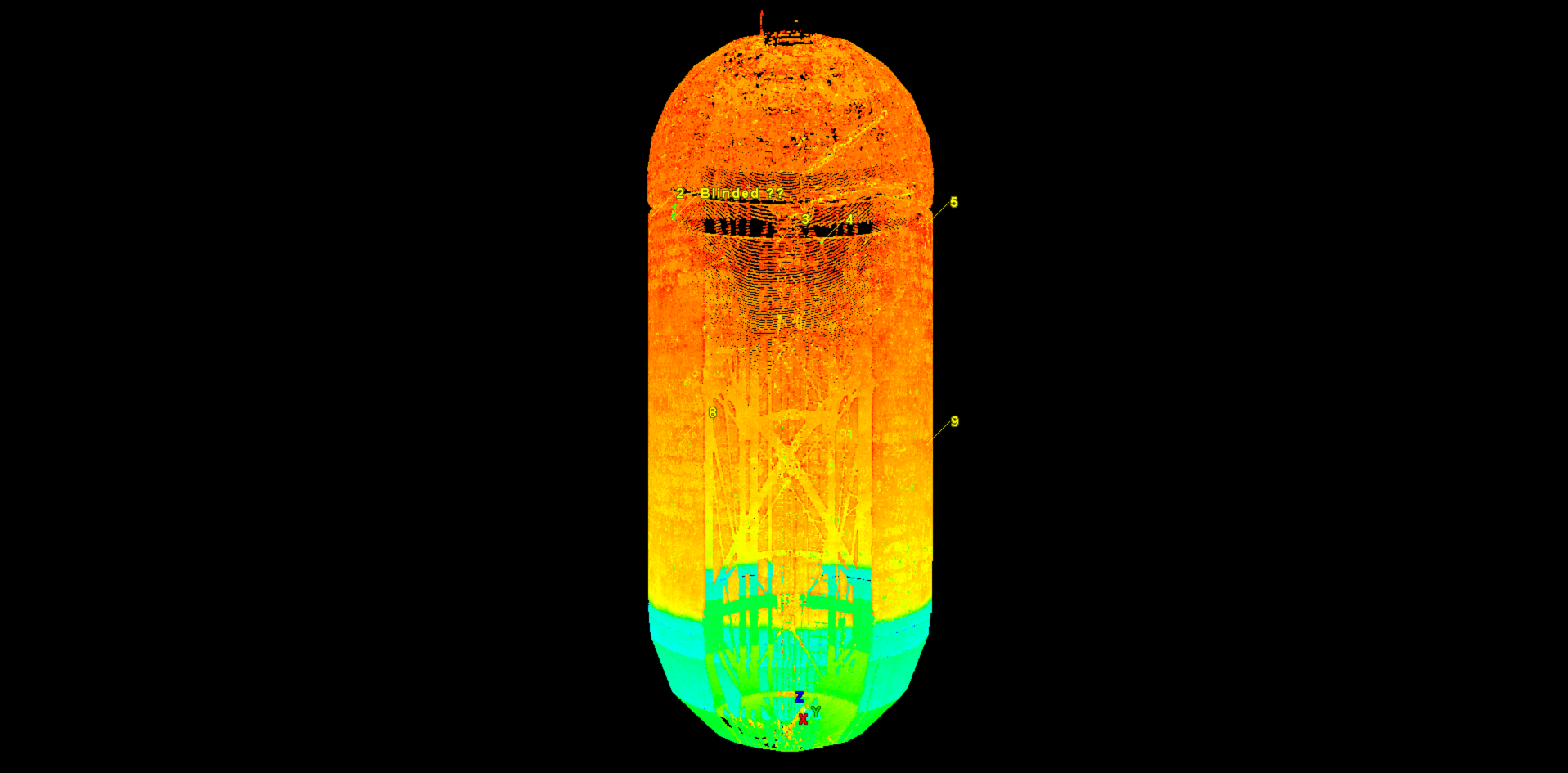
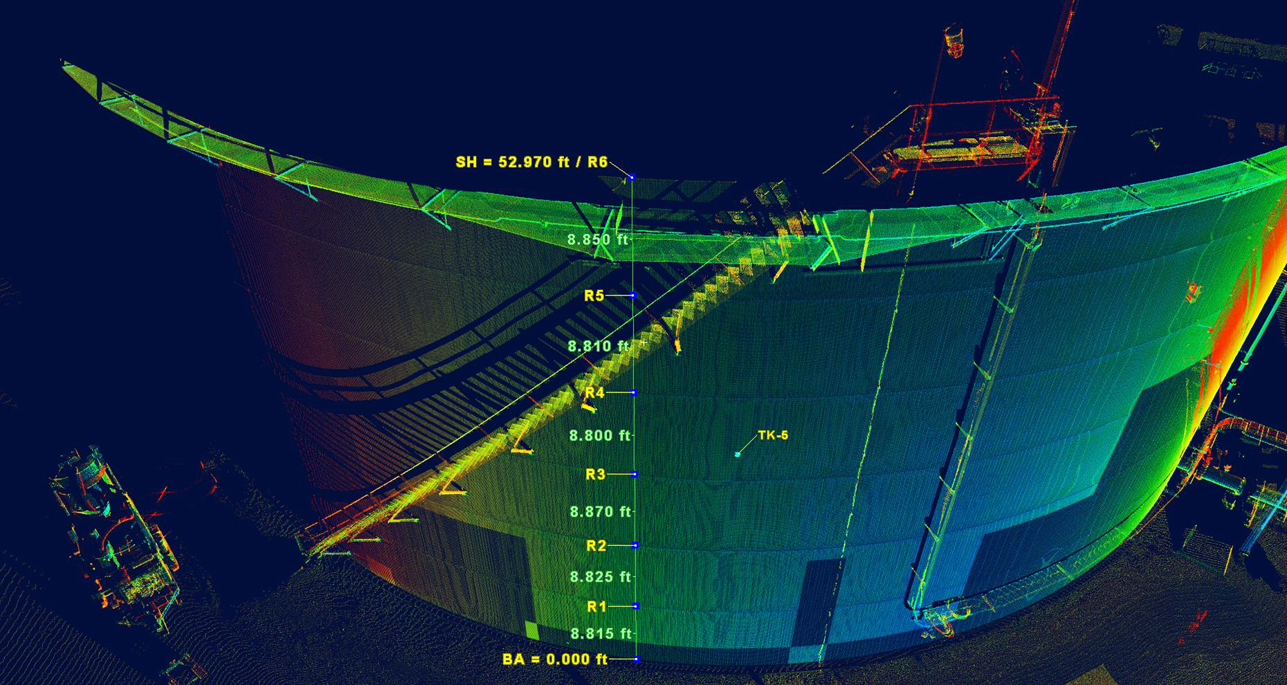
Deep within the rock of a volcanic mountain ridge, 20 steel-lined upright cylindrical tanks stand encased in concrete. Each tank measures 100 feet in diameter and 250 feet tall and can store 12.5 million gallons of fuel. Careful inspection and maintenance of the tanks is crucial to protect the region’s drinking water supply and maintain the storage facility as a strategic resource.
The tanks were scanned from the inside and outside to create registered models. The comprehensive scan data captured on the tanks could also be used to create calibration reports; manage operational risk; monitor for damage, overfill and environmental levels; and create maintenance and inspection reports.
“Instead of capturing a couple hundred measurement points on a tank, we were able to safely capture millions or billions of highly accurate points from the ground, which provided much more clarity on the tank’s condition and status,” Trask says. “We were able to bring that tank back into the office in a 3D environment and obtain measurements we couldn’t have gathered before due to the risk of inaccuracies or incomplete data.”
4. Comprehensive and Current Plant Documentation
A typical plant environment is complex and congested, with intricate networks of equipment and piping. Plant documentation often has not kept pace with the ever-changing environment. As a result, operations and maintenance must rely on flow sheets and frequent visits to the plant to obtain and verify information. When new changes are needed for upgrades or retrofits, designers and engineers must spend time in the plant capturing accurate as-is documentation before the project can begin.
These challenges can be avoided by digitizing your plant with 3D laser scanning. The resulting high-detail virtual point clouds can be quickly referenced through a few clicks on a computer or taps on a mobile device. The comprehensive and accurate data enables virtual walkdowns and true digital remote management—minimizing the amount of time workers must spend in the physical plant.
Once you’ve captured the data, you have a complete, comprehensive dataset that you can go back into at any time and continue to pull information from it. Instead of models and drawings that are outdated as soon as they’re complete, you have a living, breathing digital twin of your facility that you can continue to use over time for operations and maintenance, or future renovation projects.
CASE IN POINT
When “JIFFY” Mixes launched an initiative to upgrade its retail packaging operation, the company recognized that its plant documentation process needed to change. “The paper drawings of the plant [from the late 1960s and early 1970s] were unreliable,” said Director of Manufacturing Scott Denny. “We knew that as we continued to upgrade the facility, we would need accurate, complete documentation to do so effectively. That led us to laser scanning.”
Laser scanning enabled the company to implement its packaging equipment upgrade project quickly, safely and with minimal rework. The company sees significant potential to apply the data in other ways in the future.
“Once you’ve captured the data, you have a complete, comprehensive dataset that you can go back into at any time and continue to pull information from it,” says Michael Pfaff of Wightman, the company that handled the scanning work. “Instead of models and drawings that are outdated as soon as they’re complete, you have a living, breathing digital twin of your facility that you can continue to use over time for operations and maintenance, or future renovation projects.”
5. Secure and Accessible Plant Information
Creating a digital twin of your facilities is an important first step in maximizing safety and efficiency, but data accessibility by stakeholders is equally important. Relying on outside service providers to handle the 3D scanning on an as-needed basis, or focusing on specific projects and limited areas within a plant for design and engineering work, can cause you to miss out on valuable assets. Maximize 3D data collection by using a central infrastructure that can benefit your toolkit. Make sure personnel knows where the scans are stored and how to access them.
With the right approach, your plant data will be secure while allowing all aspects of day-to-day functions that rely on plant data to be digitally enabled. Staff will be able to visually inspect any area of the plant remotely through their web-browser. New employees can be trained through virtual walkdowns. Maintenance will know exactly where they’re going and what they’ll encounter in the plant because they’ll be able to examine the area before they get there. Engineering will be able to streamline projects by having access to measurements and visualizations with no more guesswork or discrepancies in as-built drawings.
There are no unknowns anymore. We’ve experienced significant improvements in communication and efficiency.
CASE IN POINT
A project to replace the scaffolding in a nuclear power plant service water pumphouse with a permanent access platform ignited the desire at Ontario Power Generation (OPG) to have laser scanning technology within the organization. The benefits of 3D visualization were immediately evident, and construction went smoothly with no field-initiated changes or work stoppages.
OPG embarked on a complete digital transformation under a team led by Jaydev Chauhan, project engineer for the Refurbishment Innovations at Darlington Nuclear Generating Station. The company purchased several Leica RTC360 laser scanners along with JetStream, TruView Enterprise, Register360 and CloudWorx for Solidworks software. Within six months, the scanning team had completed more than 3,000 scans for countless projects, and more than 900 internal users were finding value in the published scan data and imagery in TruView. Two years later, that number had grown to more than 2100 employees (and counting).
“There are no unknowns anymore,” says Chauhan. “We’ve experienced significant improvements in communication and efficiency.”
With the combination of the scanning and imaging technology in-house, and the greater ability to manage vendor-supplied scanning content, OPG is able to systematically maintain accurate digital records that support its digital remote management strategy. Plant modifications are scanned and published as part of a standard operating procedure to ensure the digital records stay up to date, and the benefits of the digital data continue to grow.
6. Comparative Data
The safety aspects of laser scanning extend beyond the initial data capture and reporting. Having access to comprehensive point cloud data can minimize or eliminate personnel exposure to the plant if future facility modifications are needed since the original data can often be used in engineering and design. Point clouds can also be compared to original as-builts or older scan data to identify areas of deformation before they cause problems, reducing risk and repair costs.
If an incident does occur, scan data can be used to support the investigation and identify the cause of the failure so preventive measures can be implemented.
Once you have the point cloud data, you can use it to create reports, calculate capacity, identify problem areas, manage operational risk, model spill scenarios and optimize efficiency. High definition surveying with 3D laser scanning is an enabling technology that delivers tremendous value.
CASE IN POINT
An increased focus on corporate responsibility is driving demand for high-definition secondary containment surveys, especially for facilities located near waterways and other environmentally sensitive areas. In one case, after a traditional survey indicated a potential containment capacity shortage at an oil and gas facility, the owner contracted Gauge Point Calibration to resurvey the facility with 3D laser scanning. Gauge Point’s high-definition surveys and digital data models proved the secondary containment was sufficient, saving the facility hundreds of thousands of dollars in unnecessary renovation costs.
The point cloud data also has long-term value, especially when laser scanning is used to capture entire tank and terminal operations. If future facility modifications are needed to add capacity or improve efficiency, owners and operators can return to the point cloud dataset to minimize or even eliminate the need for additional site surveys.
“Laser scanning is a very powerful intelligence tool for facility owners and operators,” says D’Arcy Trask, Gauge Point president and founder. “Once you have the point cloud data, you can use it to create reports, calculate capacity, identify problem areas, manage operational risk, model spill scenarios and optimize efficiency. High definition surveying with 3D laser scanning is an enabling technology that delivers tremendous value.”
*Statistics based on 2019 data from the U.S. Bureau of Labor Statistics, https://www.bls.gov/news.release/cfoi.nr0.htm, https://www.bls.gov/news.release/pdf/osh.pdf; see also https://www.osha.gov/data/commonstats.